Map of Africa
Map of Africa > Africa History | Africa Travel Tips |
Africa Relief Map | Africa Topo Map
 |
Africa Map Navigation
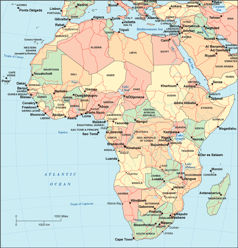
To display the map in full-screen mode, click or touch the full screen button. To zoom in on the Africa political map, click or touch the plus (+) button; to zoom out, click or touch the minus (-) button. To scroll or pan the zoomed-in map, either (1) use the scroll bars or (2) simply swipe or drag the map in any direction. (The scrolling or panning method you use will depend on your device and browser capabilities.) At any time, you can display the entire Africa map in a new window or print this page, including the visible portion of the map.

African Travel and Tourism > Africa Travel Destinations
Africa's climate and elevation variations result in a great variety of landscapes and physical features. The Sahara Desert in the north extends from east to west across the continent whereas two of the world's greatest rivers — the Nile and the Congo — flow through Africa. The Great Rift Valley is a geological feature that extends from Jordan all the way south to Mozambique. The Kalahari Desert in the south, the Atlas Mountains in the northwest, and mountain ranges near the Great Rift Valley in the east all contribute to Africa's varied topography.The largest city in Africa is Lagos, Nigeria; other leading African cities include Cairo, Johannesburg, Tunisia, and Kinshasa. Travelers from the USA may fly to Africa aboard British Airways, KLM, Egypt Air, or South African Airways. Two good sources for African news are the BBC's Africa News and the New York Times' Africa page.
Africa History and Antique Africa Map
This Africa history page provides an overview of African history and culture from ancient times to modern times. This vintage map of Africa shows the continent of Africa as it appeared in a 19th century atlas.Related Continent Map Sites
- Continental land mass map of Antarctica.
- Political, topographical, and relief maps of Asia.
- Political, topographical, and relief maps of Europe.
All rights reserved. About us.
Certain maps hereon are © Map Resources.